The Route of the Seven Lakes is one of the most famous and unmissable routes in Patagonia Argentina.
Now, what is it about?
It is a section on the famous National Route 40 that joins a San Martín de Los Andes with Villa La Angostura and its name is due to the fact that they can be visited, among others attractions, seven lakes throughout the tour (Nahuel Huapi, Lácar, Machónico, Falkner, Villarino, Lago Escondido and Correntoso)
You may be wondering how long does it take? The answer will depend on the way you decide to go through it. Since
it can be done by car, walking or with a
tourist excursion. Normally the excursions are full day but if you travel on your own, the pace to enjoy these incredible landscapes is up to you.
This time, let's to give you a guide and description of South to North very detailed about everything you can find, taking as a starting point San Carlos de Bariloche:
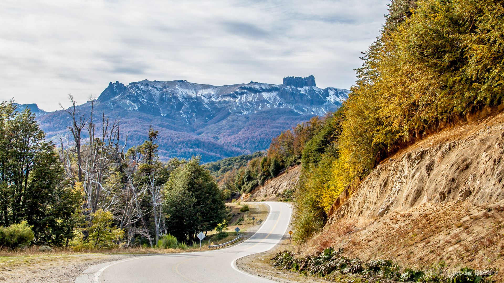
How to start the r ecorrido
Leaving from Bariloche , there are 193 kilometers to San Martín de Los Andes. First, take Avenida Costanera Juan Manuel de Rosas towards the East to connect with the National Route 40 .
In the kilometer 7.5 of this road there are a police control and then you will see the roundabout that gives access to the Bariloche International Airport . Here you just have to turn the same and continue east.
At kilometer 13, there is a descent towards the bridge of the Río Ñirihuau and you will start to be surprised with the first panoramic views that the road gives you: a view of the city of Bariloche from where you can see the hills Ventana, Otto, Catedral, López and the San Pedro Peninsula.
Following the path and arriving at kilometer 13.50 you pass by Dina Huapi (town that ends at kilometer 15 approximately). The name of this town comes from “dina”: Denmark , and from the Mapuche" huapi ": island," Isla Danesa ". It is in reference to the first immigrants who were of that origin. The use of the word Island is due to its location between the rivers Ñirihuau , Limay and the Nahuel Huapi lake .
If you are interested in entering this town, in addition to being able to enjoy its wonderful landscapes, you will to be able to visit its markets, chocolate stalls and get to know the Cerro Leones, the Limay river, the railway bridge and the historical heritage: l a old train station in Ñirihuau
Following the route of the 7 lakes, when you reach the Limay River and Nahuel Huapi Lake , you have to cross a bridge (km 17) that leaves the province of Río Negro behind to enter the province of Neuquén. eye! As soon as you cross the bridge, you will find another police checkpoint.
The route goes up and down towards a plain in the Limay River Valley and in the kilometer 20 you have to go to the left (along route 40) towards Villa La Angostura.
As you go On the way, you enter the woods and at approximately
kilometer 43 , this route enters the forest at the tip of the well-known
Brazo Huemul. If you need to stop to rest or camp, you can access the
Los Cipreses campsite (km 50) or the
Hostería Santa María (km 52).
At kilometer 66, the Brazo Huemul is left behind and on the Nahuel Huapi Lake you will be able to appreciate the peninsula de Quetrihué and the I sla Victoria. Nahuel Huapi Lake is the first of the route.
From kilometer 76 You will start to see more urbanization because you are close to Villa La Angostura (if you want to go to the city you only have to descend 3 kilometers).
It is one of the most beautiful on this route and many people visit it to enjoy its pure air, nature, tranquility and warmth of those who inhabit it. Villa La Angostura is located on the northwest of Lake Nahuel Huapi. It has one of the most picturesque mountain landscapes in Argentina. It is immersed in the Nahuel Huapi National Park , surrounded by lakes and framed in the main protected areas of Patagonia.
This city offers different attractions and activities in contact with nature such as walks through the
Arrayanes National Park, the only place in the world where there is a natural forest of this very particular species of trees. You can also enjoy the picturesque village with Alpine-style houses that accompany its landscapes. They have a
main avenue of only 6 blocks, where you can eat in the different restaurants, buy some of the typical crafts or for chocolate lovers in the
Arrayanes Avenue are the best chocolatiers of recognized brands in the area such as
Abuela Goye and Rapa Nui.
Other very beautiful places that Villa La Angostura has is the Laguna Verde, surrounded by typical vegetation that bears the name of Selva Triste . Another site highly requested by climbers and skiers is Cerro Bayo Bayo. It is located 9 kilometers from the city and its summit reaches 1782 meters high.
During your tour of Villa La Angostura you can visit the Bahía Mansa and Brava beaches. The name of each one of them explains their conditions very well. If you like calmer waters and enjoy gentle waves, you should visit Bahía Mansa, if you prefer something a little more extreme, I recommend Bahía Brava. These two bays are on each side of the isthmus that joins the Quetrihué Peninsula with the mainland.
In the case If you want to spend a night or a few days in Villa La Angostura you can do it in the
hotels that are near the main avenue or towards the hills. The most recommended are:
Ona Hotel and
La Escondida. There is also the
Camping Unquehué on Avenida Siete Lagos 727. This rural complex is an excellent option for enjoy nature. It is located within a wooded farm with views of the Andes in the Nahuel Huapi nature reserve, 1 kilometer from the homonymous lake.
Continuing the trip you will arrive at kilometer 84, where you have to take a right onto Route 40. You will find Correntoso Lake after 3 , 5 kilometers. It is one of the longest on this route, with wide beaches and bays that shelter from the wind. This blue-green water mirror is one of the most recommended places to dive, as it has waters a little "warmer" than the rest, as well as for rowing and canoeing. It is surrounded by an impressive mountain range and on the south coast there is a camping area and services for tourists.
Returning to the route, you have to follow the same path to the North and cross a bridge that passes over the Correntoso river (you are going to circulate behind the well-known
Hotel Correntoso and pay for the
“Brazo Ultima Esperanza” of Lake Nahuel Huapi with views of the Cordillera).
Important! On the Road of the Seven Lakes, when you get to kilometer 95 you will find a division:
1- To the West, the National Route 231 that t and leads to Paso Cardenal Samoré , crossing to Chile.
2- To the North, the National Route 40.
Taking the Route 40 , you will find yourself at the southern head of Mirror Lake. Its name says it all: in it you can see the reflection of the entire landscape around because of its depth and stillness. Lake Espejo is a lake of glacial tectonic origin located in the Los Lagos department. It is fed by meltwater from the surrounding mountains through several streams that flow into it. On its shores, volcanic sand beaches, reed beds and areas of steeply sloping rocks alternate. This lake extends almost to the border with Chile.
The Lake Espejo beach is wide and allows you to enjoy tours in the Andean forest. It can be accessed by car along a path 200 meters from the intersection of national routes 40 and 231. The viewpoint of the lake, is located 1 kilometer from this crossing, located on a cliff, from where you will be able to enjoy a spectacular view of the lake. In addition, it has a "Lago Espejo Chico" campsite. A quiet place to rest with incredible views and exit to the lake beach. It does not have many services, but yes, bathrooms and showers with hours of use. The pitches do not have electricity and they lend you the grill.
This wonderful place can be enjoyed all year round. The campsite is divided into 2 zones: North and South. The north has the coast of the lake and the south, the coast of the lake and the Rio Espejo.
Returning to the route, the path continues towards the North and approximately in at kilometer 115 is the access to Villa Traful. A small mountain village located within the Nahuel Huapi National Park and on the shores of Lake Traful. You will find cabins, inns, campsites, restaurants, tea houses and various sports activities are offered such as trekking, mountain biking and horseback riding.
To get to Lake Traful you have to take Provincial Route 65 (it is gravel) and cross the Paso de Portezuelo that will take you to Lake Traful. This has a 75km2 surface area and its northern arm ends in a very crowded beach called Pichi Traful, where the Camping Pichi Traful is located. Access is a bit complicated for low vehicles, ideal for utility vehicles and trucks. The campsite offers good shade, grills, a beautiful coastline and has a diving area on the beach . There is no internet or wifi in the place, it is a good way to connect with nature.
Other
recommended campsites in Villa Traful they are:
Arroyo La Maquina and
Cataratas Stream . Both have beautiful views of the
beach and the conditions of the area and services are excellent. They have bathrooms with showers and hot water throughout the day. They also offer
grocery to buy basic items such as cookies, drinks and hygiene items. To get to Camping La Maquina you have to do it at kilometer 31 of Provincial Route 65. While Camping Arroyo Cataratas is accessed by RP 65, on the way to Villa Traful. Both campsites are open from December to April.
Other recommended and well-signposted places to visit near Villa Traful are Cerro Negro and Penitentes, where you will find viewpoints to observe the imposing Lanín volcano and the Villarrica volcano.
Following the Route of the 7 Lakes, upon reaching kilometer 139, you will find the Lago Escondido. Its name arose for its location: it is hidden in a large forest and has a striking emerald green color It can be seen among the thick foliage of the coihues. The lake of glacial origin extends 900 meters from north to south and belongs to the Nahuel Huapi National Park. The maximum depth of the lake is 94 meters in the western basin and 85 meters in the eastern basin.
Returning to the road, approximately 34 kilometers from Lake Escondido (access path) you can also visit the Ñivinco Waterfall, it is a beautiful waterfall about 18 meters high, surrounded by abundant and striking vegetation. A kilometer away, you will have a very good view of Lake Villarino and at km 143 is the junction between Lake Falkner and Villarino Lake . (Both run east-west).
Both
Falkner and Villarino have beaches to stop and have a picnic, walk or lie down to contemplate the landscape. Both lakes are located
50 kilometers from the city of San Martín de los Andes. Lake Falker is surrounded by the Falkner, del Buque and Alto hills and its huge sandy beaches are ideal For resting. On its western coast there is a campsite (
Cullunche Uncuyo ) and a small inn (Dormis Unquehué).
In this area you will have the possibility to enjoy and visit the Coasts on foot or for the more adventurous, summit the Buque (1950 masl) and Falkner (2120 masl) hills. In both bodies of water, you will see fishermen since they are the most chosen lakes because in their tributaries you can catch rainbow trout, fontinalis, brown and perch.
About 3 kilometers from the lakes, is the Vullignanco Waterfall . A good option to visit! This is an unmissable postcard during your tour. It can be easily accessed from the route, it has a wide viewpoint that allows you to park the vehicle to enjoy the splendid panoramic view of the waters of the Filuco river.
Following the trip and already at kilometer 150, you enter the Lanin National Park : a place that protects an important part of the Patagonian forests. This path runs through a wide valley and 7 kilometers you will reach the Beautiful Lake. Surrounded by lengas and coihues , this 8-kilometer-long lake, deep and transparent waters, has its name well deserved.
You can access Lake Hermoso by a detour along the "Route of the Seven Lakes", 35 kilometers away from the city of San Martín de los Andes. From the Hermoso lake you can hike or horseback ride to the Cármenes Lake. It is also possible to navigate the lake to its western shore, where you can find a dense Valdivian jungle, this is a much denser and more tangled forest than that of its eastern shores, with an abundance of species such as the myrtle or larch. Here you can also sail, fish and practice water sports, due to the warm temperature of its waters, compared to Lácar or Nahuel Huapi.
The following is the Lake Machónico (about km 160). Its name comes from the Mapuche and means "shrimp lake". Why? Here, there are usually small crabs between the stones. The Machónico is one of the smallest, with an area of just 1.5 km2, but it has a striking blue color that makes it very particular. From the viewpoint located on the route you will be able to enjoy all its beauty and during the summer, in the lake you can practice water sports, kayaks and canoes.
Arriving At the end of the section and from the junction with the
Provincial Route 63 , follow the road towards the North. At kilometer 174, you have to cross the bridge over the
Arroyo Partido (notable because its waters end in both the Pacific and Atlantic Oceans). Three kilometers further on is the access to
Cerro Chapelco (Ski Center). It is located 19 kilometers from the city of San Martín and is a very popular tourist destination in the winter season. The
parking lot is located about
1200 meters above sea level , a viewpoint from which you will be able to enjoy a panoramic view of Lake Lácar with the mountain range in the background.
Chapelco is one of the most exclusive places in the country for its spectacular ski center, with slopes of varying degrees of difficulty for beginners, intermediate and expert skiers. In summer, the hill also offers other options related to adventure tourism, in addition to a Children's Park for the little ones to learn about ecology and environmental protection.
Finally at kilometer 186 is the access to
Quila Quina (18 kilometers from San Martín de los Andes) . It is the place where a
Mapuche community lives on the
Lácar Lake and that is worth knowing. This village is one of the best natural spas in the region to visit during the summer. It is
nestled on the border of the lands of the Mapuche community Curruhuinca with the Lanín National Park. You can also hire a
excursion to Quila Quina to learn more about this place, where native peoples still live. You will be able to learn more about its history and culture, admiring the beauty of the lake and the surrounding forests. This excursion is to be done if you stay to sleep in San Martín de los Andes, since it leaves every day in the morning or noon from the city.
En its impressive beaches you will be able to practice nautical sports, walks, camping and local gastronomy. In this area, there are campsites to rest or spend the afternoon while watching the sunset. The most recommended are:
Camping Quila Quina, it is located on the southern margin of Lake Lácar within the Lanín National Park. It borders the Arroyo Grande and lands of the Mapuche Curruhuinca community. The campsite is very well located on the river, accessed by a 12-kilometer dirt road. Very nice place to camp, in terms of facilities they are quite rustic. The staff is very friendly and they have a grocery store to buy food. They also have wifi and an interesting proximity to the beach and the river. It is reached by the RN 108 at Km 12, on Lake Lácar.
Other options are the Camping El Zorzal and El Catrite. Both are located 5 kilometers from the city of San Martín de los Andes. They offer grills, hot water in the morning and afternoon. They are climbing the mountain without exit to the lake.
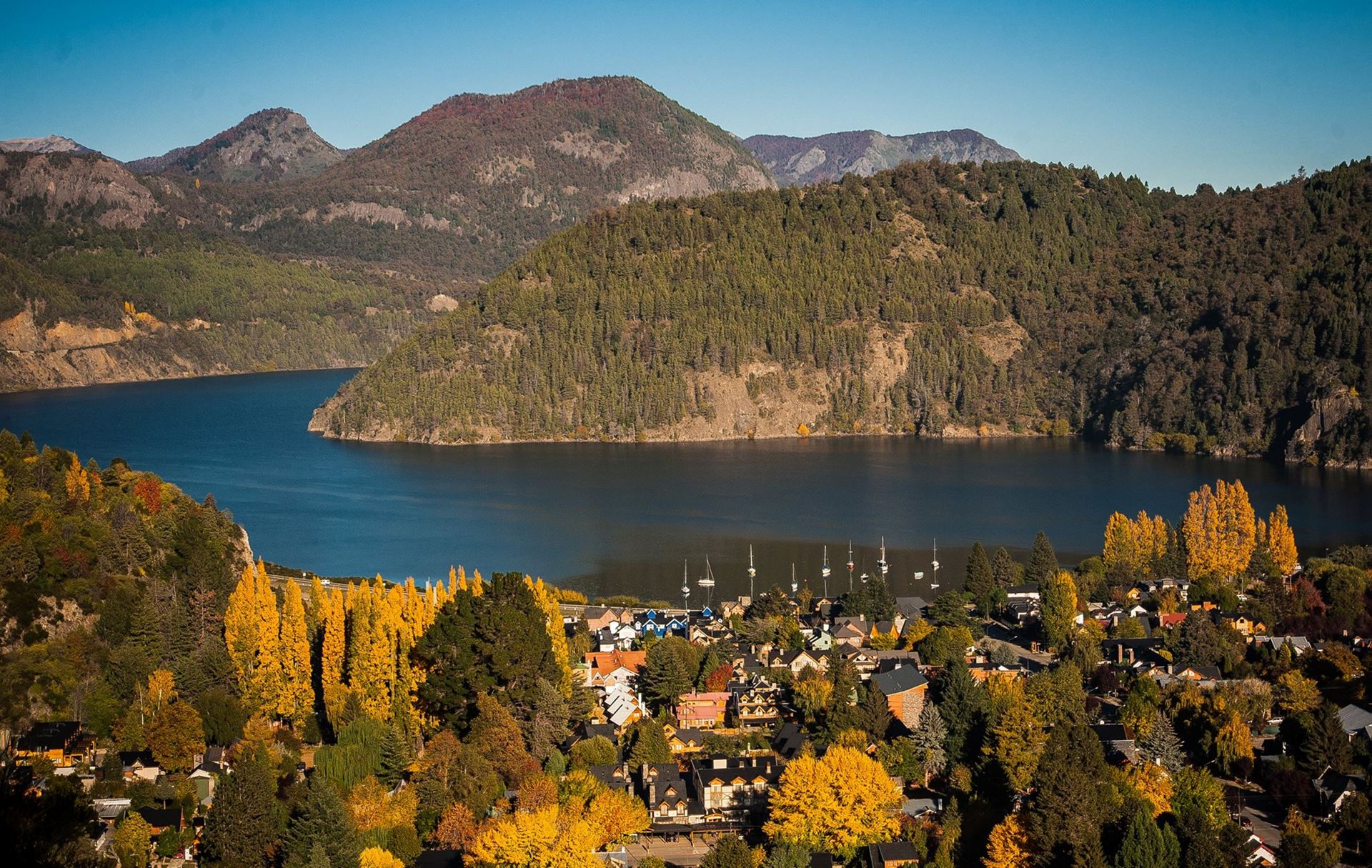
The
Lácar Lake, with an area of 49 km2, It is the last of the road and it runs along its southern coast. It is a lake of glacial origin on the Pacific slope. The name Lácar has two meanings, both from Mapudungun. The first would be formed by lai ("dead") and calcu ("witch"), its meaning would be "dead witch". The second meaning would be lar ("fallen, discarded") and carcu ("the other shore"), meaning "crumbling ravines". The city of
San Martín de Los Andes (kilometer 193), the end point of our
Route of the Seven Lakes.
San Martín de los Andes is one of the most beautiful and emblematic mountain cities of Patagonia Argentina.
Its particular architecture with stone and wood , its varied cultural offer, its options for
accommodation,
excursions and its landscapes during the 4 seasons of the year make it one of the most chosen.
Thousands of visitors come with the heat of summer to enjoy the innumerable s recreational activities that can be carried out, among which the rides on mountain biking, boating, horseback riding, trekking, ascents to the hills and, of course, fishing with trout fly.
San Martín de los Andes in winter is the perfect setting for practicing winter sports , among which skiing and snowboarding stand out. Cerro Chapelco, located a few kilometers from San Martín, is an excellent alternative to approach the snow. Both fall and spring burst into a wide range of colors. San Martín de los Andes is one of the cradles of artisan chocolate. For decades it has been a tradition that the most important chocolate shops in Patagonia settle in this charming city.
How to travel the Route of the Seven Lakes
There are different ways to travel the Route of the Seven Lakes:
- By private vehicle: is a good way to take advantage of good views and manage your times. If you don't have your own, you can rent a car for the days you want and easily.
- Hiring an excursion: if you prefer to travel with a guide, you can hire one full day excursion to visit the main attractions. nbsp ;
- By bicycle: a very cheap and fun alternative to take advantage of if the weather is warm.
The best date to visit the Seven Lakes
The region has a particular charm depending on the time of year in which it is visited. I particularly consider that the best season to travel the path of the 7 lakes is in summer, spring and autumn in that order.
Summer days have a temperature that allows you to enjoy the beauty of the landscape and even bathe in its waters. At night it is usually quite cool. It is the driest season of the year.
Winter is cold and it snows. To circulate on these routes you must have the car prepared with chains and drive with great caution. Autumn is usually cold and rainy. Although the snow or the reddish leaves of autumn can give a special color to the landscape, the most beautiful thing is being able to enjoy the beauty of the lakes. That is why it is advisable to do it in a warmer time such as spring and summer.
To take into account:
December and January: are the months with the highest movement of people and prices are higher. But if you go camping, they are the best months because all the campsites are open and well attended. Even the grocery stores tend to have a lot of stuff.
February and March: the end of the season is for those who prefer a tour with fewer tourists and a little cheaper. It is very likely that not all campsites are open.
October and November: the temperature rises a little, there are several sunny days and temperatures are good for beautiful walking tours.
Important tips
- Before starting the road, check the state of National Route 40 and fill the fuel tank well.
- If you do the way on your own, we recommend you to be careful because there is usually truck traffic (most of them are Chileans who pass to enter Chile from the Paso Cardenal Samoré, as we mentioned above).
- It can be traversed in any é time of the year. You just have to know that each season has its peculiarities: in winter the routes can freeze, in summer there are more tourists and autumn/spring is low season. It all depends on your tastes.
- Always wear warm clothes . The Argentine Patagonia is windy and even being in summer it can cool.